::: Regional Map ::: Байк, велотуризм, экипировка :::
RealBiker

ВЕЛОСИПЕД | НАВИГАЦИЯ | ЗИМА | СТАТЬИ | ОТЧЕТЫ | ДР САЙТА | КАЛЕНДАРЬ beta
ФОРУМ (Архив) | СООБЩЕСТВО | ДАЙДЖЕСТ | exГАВ | НАХОДКА
РЕМОНТ ВЕЛОСИПЕДОВ | УСЛУГИ | ССЫЛКИ | RealПОИСК | КОНТАКТЫ

  > НАВИГАЦИЯ > OZIEXPLORER > ДОКУМЕНТАЦИЯ > Regional Map

Спонсорские ссылки

OziExplorer

Документация

[ содержание ]

Regional Map

wRegionalMap.gif (21859 bytes)

The regional map window is used when using moving map (tracking) mode, it shows your position on a map loaded in the regional map window. When not using moving map mode it centers on the center of the main map.

I designed it to have display a map which covers a very large area so when tracking you can see where you are positioned relative to local landmarks (towns etc).

Loading a Map into the regional map window.

Select the Show Regional Map Window on the Moving Map menu.

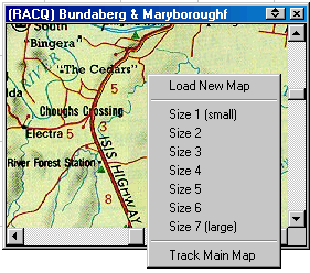
If the window is already opened then right click on the window to show a menu where the Open Map option can be selected.

Saving the Window Position

Open the window by loading a map into it, position the window where required and close it by pressing the X in the top right hand corner, from now on the window will be positioned in the same place until changed again using the same method.

Resizing the Window

Right click on the window to show a menu, select the size from the list of options. The size you select is remembered from now on until changed again.

Limitations

While any of the normal type of map images can be loaded in the regional map window the image is always fully loaded into memory. This means that TIF, BSB, Maptech and OZF maps are fully loaded into RAM (instead of being paged from disk), these maps can be quite large and there is a chance your computer may run out of resources while loading the image, in these cases the loading will be aborted.

[ содержание ]

Хотите стать спонсором раздела?

КАРТЫ

Архив
Бумага
Иные
материалы
Бланковые
карты
Карты
в Сети
Данные из космоса

ЖЕЛЕЗО

Отзывы
Мысли
FAQ
Аксессуары

СОФТ

OziExplorer
NameSearch
Генератор номенклатуры

ТОЧКИ

База точек
Природные
и культурные
объекты
Маршруты

ПРОЧЕЕ

Топосимволы
Сокращения
О картах
Лучшие фотки по оценкам пользователей:Находки:
О как размесили =). 
 (альбом Все что успел наснимать)А финишная черта - доплюнуть можно буквально!. 
 (альбом 9-летие нашего сайта)Брод через Москва-реку. Несут Рейсера.. 
 (альбом 9-летие нашего сайта)Без названия. 
 (альбом Холщевики-Тучково)Анатолия 2011. Тахталы повержена. 
 (альбом 2 недели рая)

Из комментариев к фоткам: Хе-хе))) А что случилось?)

Нашли что-то интересное или полезное? Поделитесь! =)

© Anton Chubchenko, 1999-2016


Автор не несет ответственности за использование информации и программ, содержащихся на ресурсе http://realbiker.ru.
Вся представленная информация является интеллектуальной собственностью автора(ов).
Недопустима публикация в сетях и иных источниках и/или коммерческое использование без согласия автора(ов).
По вопросам рекламы на сайте обращаться сюда.
Спонсорская поддержка сайта.
Яндекс цитирования