[ содержание ]
Moving Map Control
see also Moving Map Moving
Map Menu
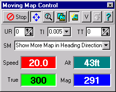
The Moving Map Control allows you to control most Moving Map options from a single
dialog.
Buttons and Fields
Start/Stop - Start NMEA communication with the GPS, or the NMEA
simulator if applicable.
Automatically Scroll Map (4 arrows) - When depressed the map will
automatically scroll to keep the GPS position pointer on screen. If not depressed the GPS
position pointer can move off the screen.
Find Maps at GPS Position - The Map File path will be searched
Check for more Detailed Map - If this button is depressed then
OziExplorer will search for a more detailed map at the interval that has been set in
configuration. If a more detailed map is found then it will be loaded.
Look for Maps in Folder of Currently Loaded Map - If this button is
depressed then when searching for a new map (leaving the current map) or for a more
detailed map the search will only be done in the folder which contains the currently
loaded map. If the button is not depressed then the "Map File path" and its
sub-folders will be searched.
Valid - Ignore the NMEA Valid Data Flag. This is for those GPS receivers which
send an invalid data flag with the data when they are in simulator mode (such as
Lowrance and Eagles and others), if the flag is not ignored no position will be plotted
when using the GPS in simulator mode.
Note : The fields described below cannot be
adjusted in the shareware version.
UR - Screen Update Rate, the interval in seconds between screen updates.
NMEA position information is still processed and track points are still collected.
Increasing the time between screen updates reduces the flickering of the other information
displayed on the screen.
TI - Track Interval, the minimum interval between track point
updates in distance units (Kilometers, Miles or Nautical Miles), or how often a track
point is collected. Setting to Zero (0) will disable the collecting of track points.
| Label |
Distance when
set to Miles
(Feet approx) |
Distance when set to Nautical Miles
(Feet approx) |
Distance when
set to Kilometers
(Meters) |
| 0 |
Disabled |
Disabled |
Disabled |
| 0.005 |
25 |
|
5 |
| 0.01 |
50 |
|
10 |
| 0.02 |
100 |
|
20 |
| 0.05 |
260 |
|
50 |
| 0.075 |
400 |
|
75 |
| 0.1 |
500 |
|
100 |
| 0.2 |
1000 |
|
200 |
| 0.25 |
1300 |
|
250 |
| 0.3 |
1600 |
|
300 |
| 0.4 |
2100 |
|
400 |
| 0.5 |
2600 |
|
500 |
| 0.75 |
4000 |
|
750 |
| 1.0+ |
1+ Mile |
1+ Nautical Mile |
1+ Kilometer |
|
While it is possible to set intervals to collect track points which are small (25ft or
5 meters etc) there is no guarantee that they can actually be collected at this interval. Example
: if you are travelling at a speed 80 km per hour (50 mph) and you receive a nmea
sentence from your GPS at 2 second intervals during that 2 seconds you have actually
traveled 44 meters so therefore track points can only be collected at 44 meter (140 feet)
intervals, no closer. This |
TT - Track Tail, how many points of the track are displayed. Displaying
too many points will slow screen refresh performance dramatically. It is best to limit the
number of points displayed. The full number of points are still collected. Setting to zero
(0) will display all points collected so far.
SM - Scroll Method, select the method to use for map scrolling.
The parameters below are read from the GPS
Sp - Speed in selected speed units (the speed units selected in
OziExplorer not the setting in the GPS).
Tr - Direction of travel (bearing), True North.
Mg - Direction of travel (bearing), Magnetic North. The Magnetic
Variation use to calculate this reading is also supplied by the GPS.
[ содержание ]


.JPG)