[ содержание ]
Importing ESRI Shape Files
Shape files are a format developed by ESRI and used in ArcInfo and other GIS packages.
see also Shape File Import/Export Options Exporting to ESRI Shape Files
Conditions and Limitations
Points, polylines and polygons can be imported.
The format of the positions stored in the shape file must be know and specified in the
Options dialog during the import process. Failure to use the correct position will give
incorrect data.
The position formats supported are Lat/Lon, UTM, Albers projection and the New Zealand
grid.
If the positions are in UTM then the UTM Zone of the positions must be known and
specified in the Options dialog during the import process. Failure to specify the correct
zone will give incorrect data.
The datum used for the positions must also be known and specified in the options dialog
during the import process. Failure to specify the correct datum will give incorrect data.
Importing Points
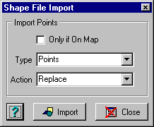
Fields
Only if On Map - The point will only be kept if they are positioned on
the currently loaded map.
Type
Waypoints - Import the points as Waypoints - Note that OziExplorer has
a maximum limit of 1000 waypoints, however this number will be reduced to the number you
have specified for your GPS in configuration. It is not advisable to load large shape
files as waypoints.
Points - Import the points as points - OziExplorer has an unlimited
number of points (until your system runs out of resources).
Action
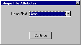
During importing the above dialog is presented. To use this dialog you need to know
somwthing about the data you are importing. You can select a DBF field as a Name Field and
the named stored in the record is used as the name of the imported point or waypoint.
If you imported the points as points then use the point control to manipulate them.
Importing Polylines or Polygons
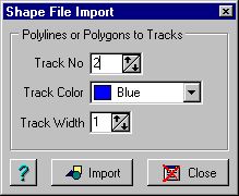
Fields
Track No - The number of the OziExplorer track to use, there are 75
tracks available (1 to 75).
Track Color - The color to use for the track.
Track Width - The width to make the track line.
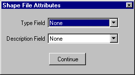
During importing the above dialog is presented. To use this dialog you need to know
somwthing about the data you are importing. You can select a DBF field as a Type Field and
a new track will be created each time the Type Field contents change. The Description
Field is used as the description of the new track.
After importing a polyline or polygon to a track use the track control to manipulate
it.
[ содержание ]


.JPG)